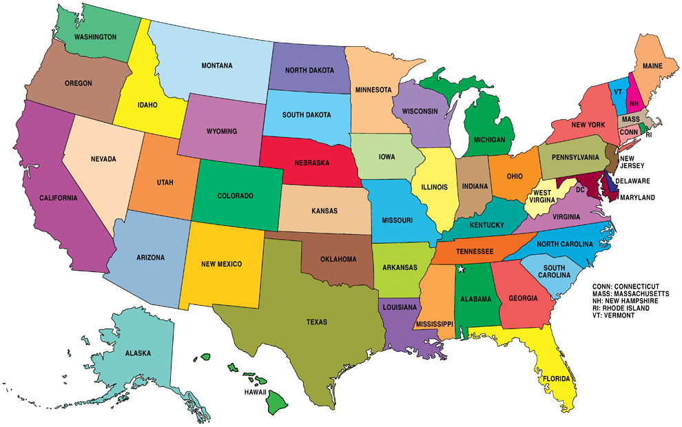
LOWEST POINT: Badwater Basin in Death Valley, California. 85 m (279 feet) below sea level.
LARGEST STATE: Alaska
SMALLEST STATE: Rhode Island
NATIONAL BIRD: Bald eagle
NATIONAL ANTHEM: «The Star-Spangled Banner» by John Stafford Smith.
ASSOCIATE TERRITORIES: Puerto Rico, Guam, Islas Marianas del Norte, Samoa Americana, Islas Vírgenes de los Estados Unidos.
PHISYCAL FEATURES
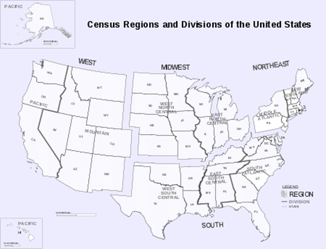
Different regions or areas:
REGION
1:
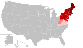
Northeast
The region has a total area
of 469,630 km2 with 420,240 km2 of that being land mass.
With an average of 345.5 people per square mile, the Northeast is 2.5 times as densely populated as the second-most dense region, the South. Since the last century, the U.S. population has been shifting away from the Northeast (and Midwest) toward the South and West.
REGION
2:
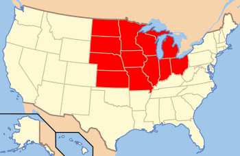
Midwestern
Today the population of the Midwest is 65,971,974, or 22.2% of the total population of the United States.
REGION
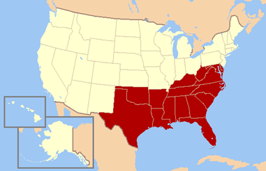
3:
South
An estimated 122,696,385 people, or thirty-seven percent of all U.S. residents, lived in the South, the nation’s most populous region.
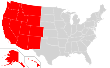
REGION
4:
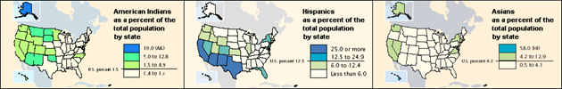
West
The population distribution by race in the Western United States:
PHYSICAL RELIEF
Mountains
Rivers and lakes
Climate
The climate of the United States varies due to differences in latitude, and a range of geographic features, including mountains and deserts. Generally, on the mainland, the climate of the U.S. becomes warmer the further south one travels, and drier the further west, until one reaches the West Coast.
The name of our group is Diana Frances Spencer, better known as Lady Di.
Lady Di (born 1 July 1961 – 31 August 1997), was a member of the British royal family. She was the first wife of Charles, Prince of Wales, the heir apparent to the British throne, and the mother of Prince William, Duke of Cambridge, and Prince Harry, Duke of Sussex.
After her divorce from the Prince of Wales in 1996, officially, she ceased to be the Princess of Wales. From the time of her engagement to the Prince of Wales in 1981 until her death in a car accident in 1997, the Princess was arguably the most famous woman in the world, the preminent female celebrity of her generation: a fashion icon, an image of feminine beauty… During her lifetime, she was often referred to as the most photographed person in the world.
Flower: Rose; Animal: Lion; Saint: St. George; Colour: white, red and blue.
WALES
The national symbols of this country are:
Flower: Daffodil; Animal: Dragon; Saint: St.David; Colour: red, green and white.
SCOTLAND
The national symbols of this country are:
Flower: Cardo; Animal: The Unicorn; Saint: St. Andrew;Colour: white( argent) and blue ( azure).
IRELAND
The national symbols of this country are:
Flower: Shamrock; Animal: Red Deer; Saint: St. Patrick; Colour: In British usage, it refers to a sky blue used by the Order of St. Patrick. While green is now the national colour of Ireland.
Maps
The main cities in UK and Eire are these ones:
Physical features
Location: Western/ Northern Europe
Area: The total area of the United Kingdom according to the Office for National Statistics is 248,532 square kilometres (95,960 sq mi), comprising the island of Great Britain, the northeastern one-sixth of the island of Ireland (Northern Ireland) and many smaller islands. England is the largest country of the United Kingdom, at 132,938 square kilometres (51,330 sq mi) accounting for just over half the total area of the UK. Scotland at 80,239 square kilometres (30,980 sq mi), is second largest, accounting for about a third of the area of the UK. Wales and Northern Ireland are much smaller, covering 21,225 and 14,130 square kilometres (8,200 and 5,460 sq mi) respectively.
Population:
The current population of the United Kingdom is 66,804,146 as of Tuesday, February 5, 2019, based on the latest United Nations estimates.
The United Kingdom population is equivalent to 0.87% of the total world population.
The U.K. ranks number 21 in the list of countries (and dependencies) by population.
The population density in the United Kingdom is 277 per Km2 (717 people per mi2).
The total land area is 241,930 Km2 (93,410 sq. miles)
81.4 % of the population is urban (54,511,753 people in 2019)
The median age in the United Kingdom is 40.3 years.
Physical Relief of UK and Ireland
Relief
Great Britain can be roughly divided into two main regions:
Lowland Britain and Highland Britain.
Lowland Britain lies mainly in the south-east of England.
Highland Britain includes the whole of Scotland, the Lake District (north-west England), the south and the south-west of England (Cornwall and Devon), and almost the whole of Wales.
It comprises the following ranges of mountains and hills:
The Scottish Highlands – the highest mountains in the British Isles. They consist of two parts,
the Northwest Highlands and
the Grampian Mountains.
The highest peak in the British Isles, Ben Nevis (1,343 m), is in the Grampians.
The Southern Uplands – low hills in the southern part of Scotland, separated from the Scottish Highlands by the Central Lowlands, containing three-quarters of the population and most of the industrial centres. Although called the Lowlands, this area is quite hilly too.
The Cheviot Hills – a natural border between England and Scotland.
The Pennines – called the «Backbone of England», the longest chain of mountains, situated in the central part of northern England.
The Cumbrian Mountains – known as the Lake District; their highest peak Scafell Pike (978 m) is the highest mountain in England.
There are some low rangers of hills in the south-west (Exmoor, Dartmoor) and in the south (the Cotswald Hills, the South and the North Downs) of England.
The Cambrian Mountains – these occupy most of Wales; the highest mountain is Snowdon (1,085 m).
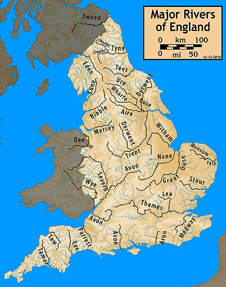
Rivers
ENGLAND
WALES
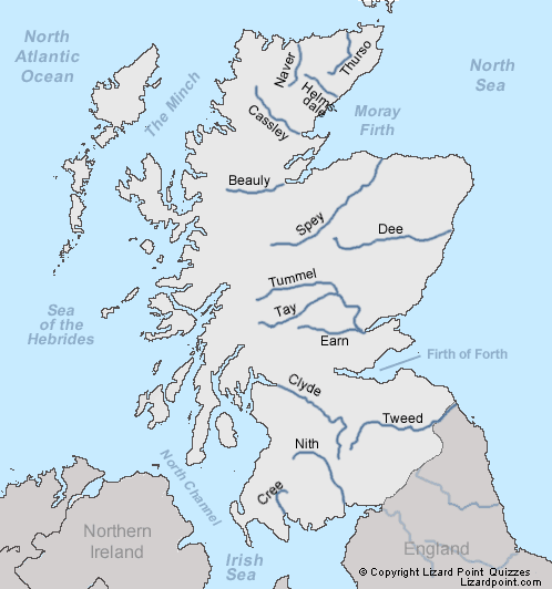
SCOTLAND
IRELAND
Climate
The climate in Britain is generally mild and temperate due to the influence of the Gulf Stream – a warm sea current flowing from the Gulf of Mexico to western Europe. The characteristic features are not very hot summers, mild winters, frequent changes in weather, but few extremes of temperature, abundant rain all the year round (but on average, March to June are the driest months, September to January the wettest). More than one half of the days are overcast.
Britain’s weather is influenced by westerly winds blowing from the Atlantic, mild in winter, cool in summer, bringing rain and fog. Occasional easterly winds in winter may bring a cold, dry, continental-type of weather. It seldom snows heavily in winter.
Economy: agriculture, main energy resources and main industry
ENGLAND
The economy of England is the largest economy of the four countries of the United Kingdom. England is a highly industrialised country. It is an important producer of textiles and chemical products. Although automobiles, locomotives, and aircraft are among England’s other important industrial products, a significant proportion of the country’s income comes from the City of London.
The economy of Wales is closely linked with the rest of the United Kingdom and the wider European Economic Area.
Agriculture in Wales has in the past been a major part of the economy of Wales, a largely rural country that forms part of the United Kingdom. Wales is mountainous and has a mild, wet climate. As a proportion of the national economy, the importance of agriculture has become much reduced; a high proportion of the population now live in the towns and cities in the south of the country and tourism has become an important form of income in the countryside and on the coast.
SCOTLAND
Scotland was one of the industrial powerhouses of Europe from the time of the Industrial Revolution onwards, being a world leader in manufacturing. This left a legacy in the diversity of goods and services which Scotland produces, from textiles, whisky and shortbread to jet engines, buses, computer software, ships, avionics and microelectronics. Scotland has seen a decline in the importance of both manufacturing industries and primary.
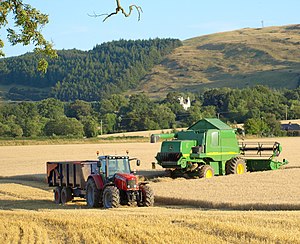
Agriculture in Scotland includes all land use for arable, horticultural, pastoral or hunting activity in Scotland, or around its coasts. The first permanent settlements and farming date from the Neolithic period, from around 6,000 years ago.
IRELAND
The economy of Northern Ireland is the smallest of the four countries of the United Kingdom. Northern Ireland previously had a traditionally industrial economy, most notably in shipbuilding, rope manufacture and textiles, but most heavy industry has since been replaced by services. Rural areas including the North West are particularly deprived. It suffers from the highest unemployment and highest poverty rates in Northern Ireland. Infrastructure is substandard and has hampered economic development.
The long history of agricultural production, coupled with modern intensive agricultural methods such as pesticide and fertiliser use and runoff from contaminants into streams, rivers and lakes, impact the natural fresh-water ecosystems and have placed pressure on biodiversity in Ireland. About 6% of the agricultural acreage is used for growing cereals, 1.5% for growing root and green crops, and the balance for pasture and hay. Thus most of the farmland is used to support livestock, the leading source of Ireland’s exports. Most farms are small, although there has been a trend toward consolidation.